Satellite Deformation Monitoring & Risk Intelligence

You can't stop the ground from moving.
But you can prevent what comes next.

PSTool helps dam owners, transport operators, utilities, engineers, and mining teams turn satellite-derived ground motion into prioritized alerts, decision-ready reports, and exportable evidence for maintenance, safety, and risk workflows.

Developed by Earth Observation experts at Terrasigna  |  Used to understand past behavior, monitor change and support operational decisions around critical assets

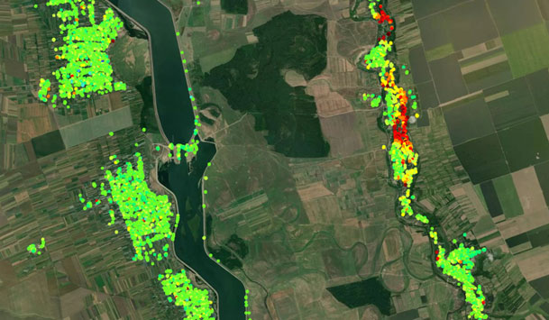
Relying solely on ground sensors leaves dangerous blind spots.


Ground instrumentation and leveling campaigns remain essential, but they only show what is happening where sensors already exist. Across dams, rail embankments, roads, utilities, mines, and surrounding slopes, meaningful deformation can develop outside those points and remain unnoticed until it becomes harder and more expensive to investigate. PSTool extends your view with wide-area, historical, and ongoing satellite monitoring so your team can see the bigger picture, identify emerging hotspots earlier, and direct field checks where risk actually deserves attention. It complements field instrumentation; it does not replace it.

InSAR monitoring overview
InSAR deformation map

What PSTool enables you to do

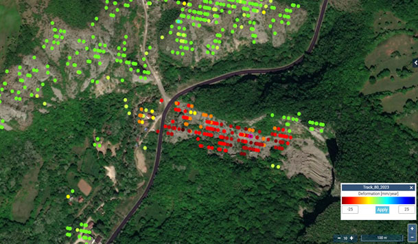
1. Spot change earlier.

Wide-area monitoring helps you identify emerging deformation patterns before they become visible in the field or escalate into a costly surprise.

2. Build the baseline before decisions get expensive.

Historical observations help you distinguish long-term behavior, seasonal movement, localized issues, and accelerating trends before construction, maintenance, or claims decisions.

3. Prioritize inspections and interventions.

Focus crews on the locations showing meaningful motion, not just the locations that are easiest to access or already instrumented.

4. Document decisions with defensible evidence.

Use time series, hotspot screening, transects, and exports to support maintenance reviews, engineering discussions, stakeholder communication, and internal risk workflows.

5. Integrate ground motion into existing operations.

Bring in asset layers, export findings into GIS and engineering workflows, and add expert interpretation when your team needs support translating movement patterns into operational decisions.

Built for industries where early warning protects critical assets


PSTool is built for owners, operators, engineers, and maintenance teams who need to understand both the asset and the surrounding ground behavior.

Dams and Reservoirs

Monitor embankments, crest areas, reservoir slopes, and surrounding ground behavior to support dam safety reviews, prioritize follow-up investigations, and add historical context before costly interventions.

Railways, Roads, Bridges and Embankments

Screen long corridors for differential settlement, slope movement, and localized deformation so maintenance teams can focus field checks where risk is actually emerging.

Utilities and Underground Networks

Detect ground movement that may threaten distributed or underground assets and use asset-oriented screening to prioritize preventive maintenance and support network risk workflows.

Mining, Quarries, and Tailings-related Assets

Screen large operational areas, pit walls, tailings surroundings, and evolving deformation patterns as part of broader geotechnical risk management.

Also valuable for engineering and geotechnical teams involved in site selection, design assumptions, construction oversight, and post-construction review.

From Satellite Data to Decisions


PSTool combines satellite-derived ground motion monitoring with Terrasigna processing, quality assurance, and investigation tools built for decision-making.

Platform Capabilities

  • Interactive time-series profiling and temporal averages
  • Layered filtering by velocity, height, and uncertainty
  • Multiple base maps plus optional custom operational layers
  • Directional displacement views where available
  • Transect analysis for corridors and linear assets

What You Get


  • Access to the PSTool web platform for your selected asset, site, corridor, or portfolio
  • Historical and updated displacement time series
  • Area-based screening and hotspot investigation
  • Transect analysis for corridors and linear assets
  • Exportable outputs for GIS, engineering review, and stakeholder reporting
  • Optional custom layers and asset context overlays
  • Optional periodic review by Terrasigna experts

Built for action, not just visualization


Alerts

Set thresholds for meaningful changes in movement behavior so the right people know when a review is needed.

Reports

Support routine monitoring updates, management reviews, and asset or compliance discussions with clear, repeatable outputs.

Exports

Move findings into GIS, engineering, and stakeholder communication workflows without recreating the analysis manually.

Integration

Use custom layers and, where needed, connect outputs to your asset, GIS, BIM, or broader monitoring environment.

Expert Interpretation

Add Terrasigna specialists when your team needs help translating movement patterns into operational priorities, escalation criteria, or next-step investigations.

Built for real-world monitoring and engineering workflows

PSTool is developed by Earth Observation experts at Terrasigna and designed for infrastructure, operations, and engineering teams that need clear, decision-ready outputs without processing SAR data themselves.

Developed by an Earth Observation company with long-term experience in satellite data processing
Designed to move from data to decision, not just visualization
Built on methodologies used in large-scale satellite monitoring projects
Supports historical investigations, ongoing monitoring, and exportable evidence

Flexible monitoring tiers to fit your asset lifecycle.


Start with a focused historical review, prove the value on one asset, then expand into recurring monitoring where the risk profile and operational need justify it.

Tier 1

Historical Baseline Audit

Best for site selection, liability reviews, pre-construction understanding, and questions about whether an issue is long-term, localized, seasonal, or accelerating.

  • One-off historical review and expert summary
  • Platform access to the selected area
  • Hotspot screening, time series, and exportable evidence
  • Recommendation on whether ongoing monitoring is justified
Tier 3

Enterprise & Sensor Fusion

For critical assets or portfolios that require higher service levels, broader deployment, or integration into existing monitoring environments.

  • Portfolio or corridor-scale rollout
  • Optional higher-resolution or commercial data configurations
  • Integration into internal dashboards and reporting environments
  • Dedicated expert support

Recommended commercial path: start with a pilot or historical baseline audit, then expand to a site portfolio, corridor program, or enterprise deployment.

Free Guide

The Buyer's Guide to Satellite Ground Motion Monitoring for Dams, Corridors, and Utilities

What free data can show you, what it cannot, and what to ask before you buy a commercial monitoring service.

Free Guide Soon PDF will be available shortly.

Frequently Asked Questions


No. PSTool is designed for infrastructure and engineering users who need to investigate ground motion without processing SAR data themselves.

No. PSTool extends spatial coverage, adds historical context, and helps focus on-site monitoring and inspection decisions. It works best alongside field investigation and instrumentation.

Yes. Historical review is one of the strongest entry offers because it helps teams understand whether current issues are long-term, localized, seasonal, or accelerating.

Yes. Exports are intended to move findings into engineering, GIS, reporting, and internal risk processes.

Yes. A pilot or single-asset deployment is the recommended commercial entry point. From there, the program can expand to a corridor, site portfolio, or enterprise setup.

Public portals can provide useful displacement data, but they typically do not offer asset-specific setup, tailored alerts, decision workflows, contractual reporting, or expert support around your infrastructure.

Ready to stop guessing about ground stability?


Talk to our InSAR specialists today. We can review your asset, recommend the right delivery model, and, if you share a location, prepare a preliminary historical scan to reveal the patterns that may already be developing beneath the surface.

One of our specialists will contact you within 24 hours to arrange a tailored session.